Redstone Bridge

Nestled in the heart of South Central Minnesota lies the German influenced town of New Ulm. This town was founded in 1854, and the Chicago & North Western Railway arrived in late 1871. New Ulm became a significant station point for the C&NW, and included a crossing of the Minnesota River. By 1899, a line relocation made the river crossing redundant, and the original mainline was reduced to a branch. The line was purchased by the Dakota, Minnesota & Eastern Railroad in 1986; which was in turn purchased by Canadian Pacific Railway in 2008.

47914-2
Looking east across the Redstone Bridge

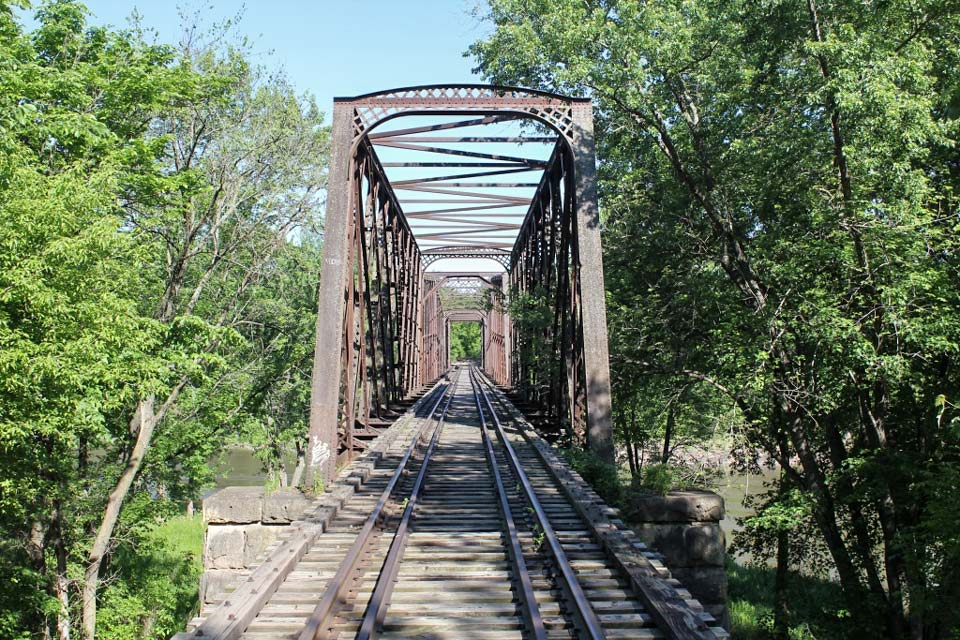
The Redstone Bridge lies just east of New Ulm, along the original mainline. It is named after the town of Redstone, a long lost town along the banks of the Minnesota River. The bridge is hard to access, but is a treat for anyone that visits. A serene and quiet spot surrounds this very historic swing bridge, which is a little known secret. The bridge was originally built in 1880 to replace a wooden swing bridge. The bridge was built under the direction of the Chicago & North Western Railway, with the Leighton Bridge & Iron Works of Rochester, New York erecting the structure.

Overview of swing span

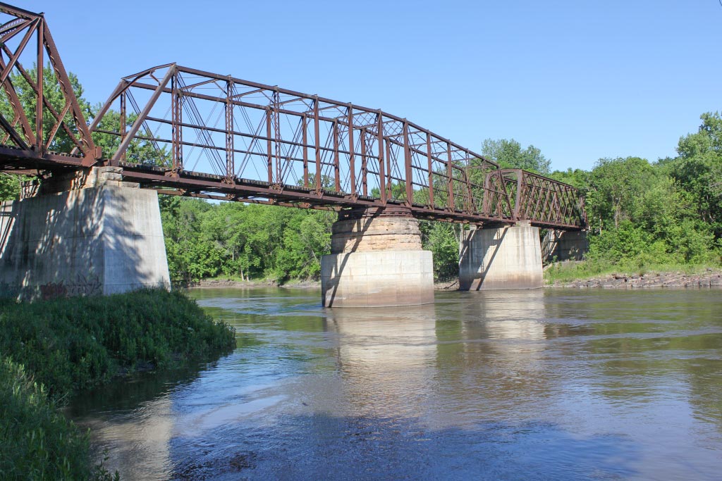
The center swing span is a 206-Foot-long Iron Swing Span, of Camelback Through Truss construction. The span is set on iron rollers, on top of a round stone pier. The span uses a unique system of U-Bolts to hold the structure together. The swing system is still fully intact.

U-Bolt Connection
U-Bolt Connection

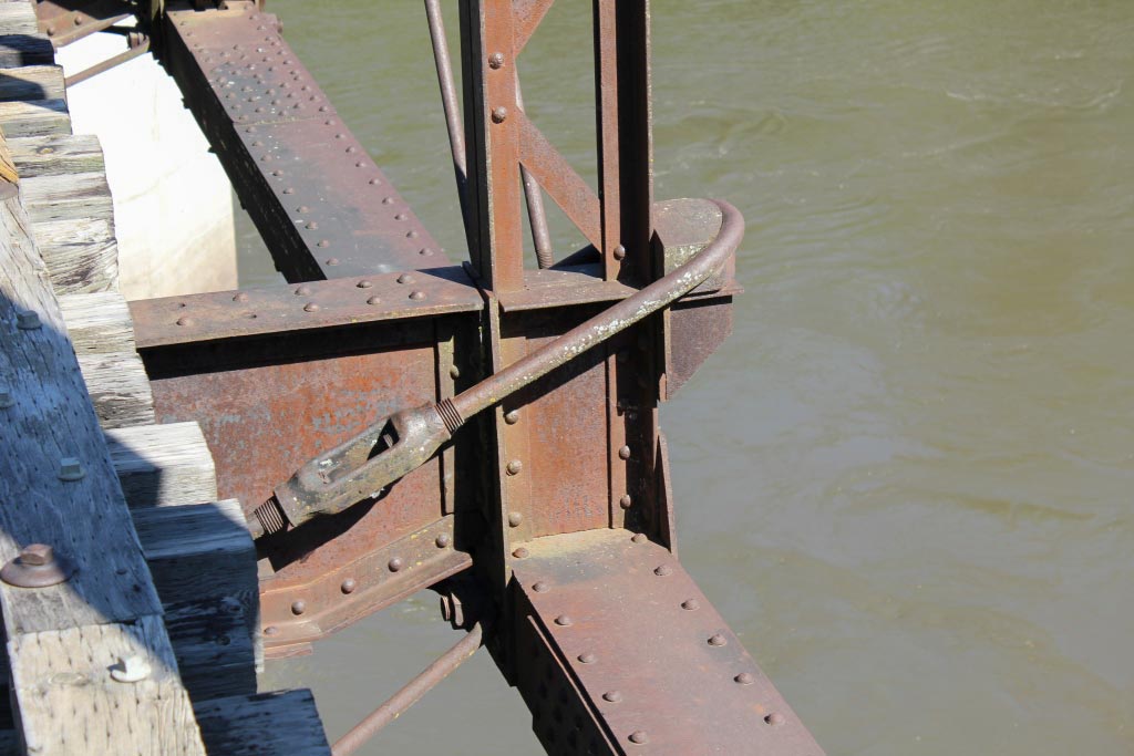
The swing span is approached on either side by a 130 Foot Quadrangular Through Truss, of iron construction. This design is exceedingly rare in certain parts of the United States, although it is very common along former C&NW lines. Post Tension Rods connect pieces on these spans, allowing for heavier loads with less material.

The West Approach Truss

In addition to the main through trusses, the bridge also has a wooden trestle approach. Stone piers are also used for the trusses, although all but one has been encased in concrete. Presently, the bridge serves a quarry to the east. Various agencies hope that if abandoned, this highly significant bridge can be preserved in the form of a trail. Access to it is walk in only, from 171st Avenue.

The bridge serves as a reminder to a past time, when riverboats and trains crossed paths. While the Minnesota River became non-navigable this far upstream in 1884, the bridge undoubtedly had to swing at least once. The bridge also serves a reminder of the heritage of the community of New Ulm, which was brought up along the railroad. With an excellent retention of historic integrity, the bridge is commonly regarded as one of the most significant railroad bridges in the State of Minnesota. Despite its relatively unrecognized status, the bridge is also one of the more significant railroad bridges in the United States. Hopefully it can retain this status through preservation for years to come.

John Marvig Photographs and Text Copyright 2016

See more of John’s work at John Marvig’s Railroad Bridge Photography

Built to last

One hundred years ago, when airplanes had just been invented, and automobiles were not affordable for most people, transportation in the growing United States was provided mostly by railroads. One of the busiest and most successful was the New York, New Haven, and Hartford Railroad. The New Haven reached throughout Connecticut, Rhode Island, Massachusetts, and parts of New York State. New England’s factories were busy manufacturing goods for most of the country, and shipping raw materials in and finished products out made the New Haven a prosperous and growing business.

Traffic demand between New Haven and New York grew to the point that the railroad decided to invest in two infrastructure improvements. The first eliminated grade crossings by elevating or depressing the tracks through populated areas between New Haven and Mount Vernon. From there, trains ran down the New York Central tracks into Grand Central Terminal. The second improvement was to electrify the four track main line, which was completed in 1907 between Mount Vernon and Stamford, and extended to New Haven in 1914. The New Haven’s innovations resulted in the first commercially successful, large scale electrified railroad in the world.

A key location in the system was Stamford, Connecticut. The New Haven operated a robust commuter railroad service with frequent trains serving the towns along the new tracks, which quickly expanded the suburbs of New York City, making it possible for commuters to return home after work in the City with ease and in relative comfort.

Stamford, Connecticut - 1966
Stamford, Connecticut – 1966

This photo was taken in summer of 1966. The view is from the eastbound platform at Stamford, facing west. The overhead wires are the New Haven’s innovative design using a triangular structure which held the catenary wires in a fixed position over each of the four tracks. In the left background, an express passenger train, powered by an EP-5 class locomotive, is just coming into view around the curve and is about to pass under the semaphore signal displaying “Medium Clear”. The engineer has reduced speed to 30 mph, and shortly his train will clatter over the switches, set to crossover from track 2 to track 4, and make the station stop.

On the right, the signal semaphores controlling westbound traffic are set for “Clear” on track 3, allowing the next “Stamford Local” to depart on time and make all stops to Mount Vernon and on to GCT. The three boys at the end of the platform are enjoying mainline passenger railroading up close.

In the next fifty years, there will be many improvements to the New Haven. High level platforms, modern cab signaling, a superior lightweight catenary system, new locomotives and new commuter cars, and modern electronic systems will make the commuters’ journey more frequent, more comfortable, and more reliable. Today the system is still providing the service it was designed to do by the forward thinking managers of the New Haven Railroad one hundred years before. It was built to last, and it has.

logo-1960-new-haven-railroad

Bob HughesPhotograph and text copyright 2016

Santa Fe Depot

The San Diego, CA, station was built by Santa Fe in 1915 and was the terminal for the railroad’s San Diegans until Amtrak took over in 1971. Passenger trains of SP’s San Diego & Arizona Eastern also originated here from 1919 to 1951. Today it is the terminal for Amtrak, Coaster, and several lines of the San Diego Trolley.

Santa Fe Depot - San Diego, California - September, 1970
Santa Fe Depot – San Diego, California – September, 1970

The Mission Revival architecture includes interesting tile work.

Santa Fe Depot - May, 2010
Santa Fe Depot – May, 2010

Gordon Glattenberg – Text and photographs Copyright 2016

End of the line

In June of 2014, my wife and I flew from Cleveland, OH, to Yuma, AZ, to help take care of our daughter’s two rambunctious boys while a third was being born. There wasn’t much time for railfanning or photography, but I squeezed some in. I looked on Google Maps to see where train tracks were in Yuma, and where there might some interesting photography. One spot intrigued me, with a few tracks twisting around and not going anyplace. When I got there, I found this old building.

Loading Platform
Loading Platform

Rob Richardson – text and photograph Copyright 2016
See more of Rob’s work at: Where Trains Were


Montpelier

James Madison, the fourth President of the United States, lived at Montpelier plantation until he died in 1836. In 1901, the DuPont family acquired the property which they owned until 1985. In 1910 William DuPont financed the construction of the train station to provide both freight and passenger service to the Montpelier community. Passenger service was discontinued in the 1960s and the freight depot was closed in 1974. Today Norfolk-Southern freight trains pass by the depot, but rail service to Montpelier is a thing of the past.  The station was built to a Southern Railway standard architectural plan.

Montpelier_P14807

Montpelier is now owned by the Montpelier Foundation and the station,  has been restored. Part of the station houses a small museum and one end  serves as the U.S. Post Office for Montpelier Station, Virginia.  The active Norfolk-Southern tracks are just out of view on the right of the picture above.

Montpelier_P14798

Also on the grounds is a small freight house. There was once a siding that ran in front of the building and ended in a coal loading trestle just beyond. Montpelier Station is located in Orange County, Virginia. All photos were taken in December, 2015.

Montpelier_P14814

Edd Fuller – Photographs and text Copyright 2016