Toledo Union Station

Toledo Union Station - To Trains
Toledo Union Station – To Trains

The city of Toledo, Ohio, has a fascinating railroading history, of which I know almost nothing.  Trains run through between the East Coast and Chicago, and between Columbus and Detroit, and any possible combination.  In the early days of railroading, in the late 19th century, cooperation between railroads basically did not exist.  As a result, instead of trying to share tracks and other facilities, many different railroads built tracks to or through Toledo.  Even today, Google Maps shows an amazing collection of tracks going every which way.

Toledo Union Station - End of Track
Toledo Union Station – End of Track

A central passenger railroad station was built in Toledo in 1886, but by 1930 it was so decrepit that when it caught fire, watching citizens cheered.  They were sad later, when the structure was repaired instead of replaced.  A couple of decades later, in 1950, they got their wish, and the new Toledo Union Station was opened.

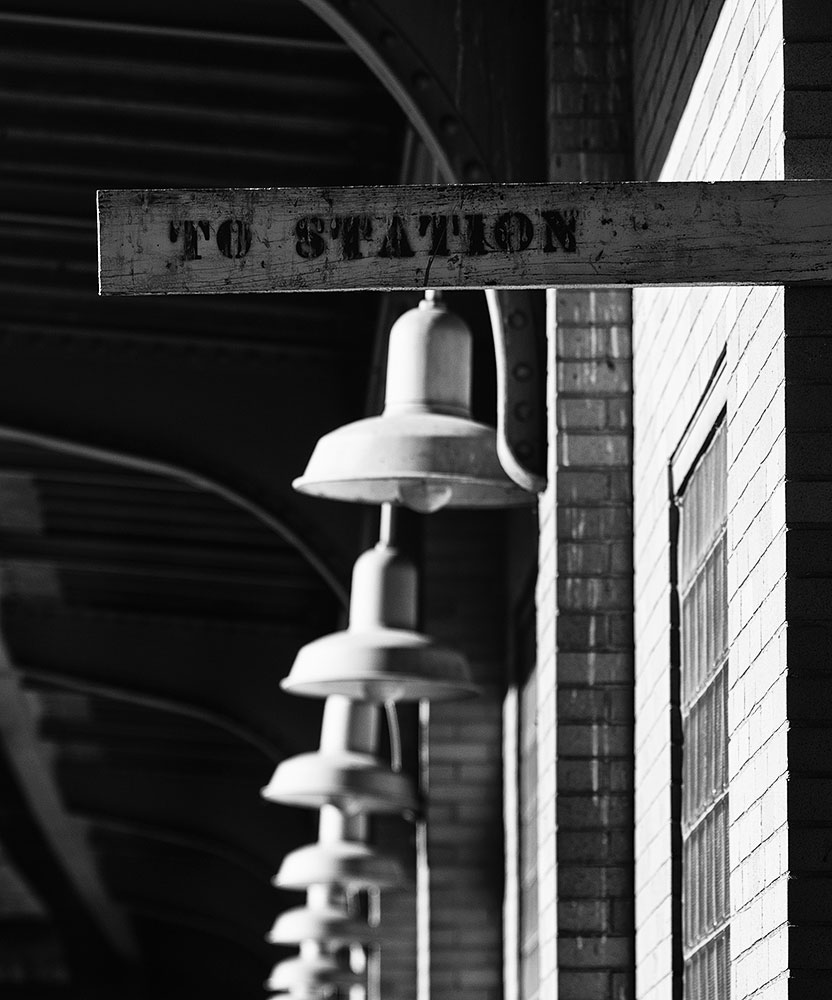
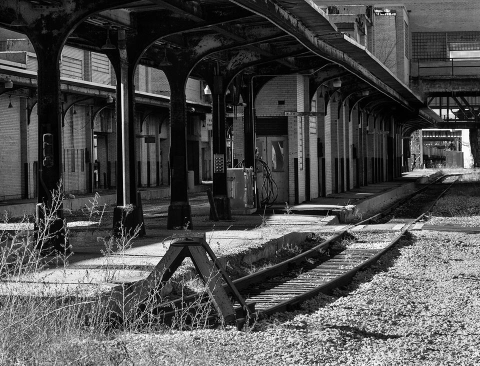
That was still in the glory days of passenger rail transportation, and its many tracks and platforms would have been constantly busy.  But, as time went on, we all know the fate of passenger rail.  Today, the station houses a nice waiting room for Amtrak’s four trains per day. That’s all the passenger traffic it sees.  Freight trains pass on the main Norfolk Southern line, frequently stopping for crew changes.

Toledo Union Station - Empty Platform
Toledo Union Station – Empty Platform

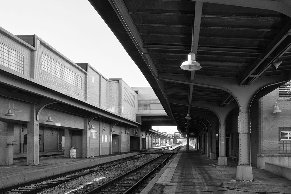
During the Christmas holiday of 2013, I had a day to spend exploring northwest Ohio and visiting Fostoria, a favorite location.  One of my stops was Toledo Union Station.  It is still an impressive building, but I think the station must feel sad to be used so far below its potential.  I wandered its empty platforms, wondering what they would have looked like when they were crowded with passengers, and porters, and train crews, and trains everywhere.  They’re not there any more.

Rob Richardson – Photographs and text Copyright 2016

See more of Rob’s work at: Where Trains Were

Demise of the New River Bridge

New River Bridge - Glen Lyn, Virginia - April, 1968
New River Bridge – Glen Lyn, Virginia – April, 1968

The former Virginian Railway bridge over the New River at Glen Lyn, Virginia was perhaps one of the most spectacular railroad crossings constructed at that time. Designed in 1906 by the Tidewater Railway, the bridge was completed in 1909 after the new Virginian Railway was formed by merger of the Tidewater with the Deepwater Railway which was building eastward from its namesake town in West Virginia. Both the Deepwater and the Tidewater railways were constructed by financier Henry Huttleston Rogers. After the Chesapeake & Ohio and the Norfolk & Western railways refused to give the little Deepwater favorable rates for shipping coal from the mines in southern West Virginia,  Rogers quietly incorporated the Tidewater railway to build westward from Norfolk to the West Virginia state line. In 1907 the Tidewater name was changed to the Virginian Railway (reporting mark VGN) and at the same time the Deepwater Railway was acquired by the VGN. There was a gap between the former roads until 1909 when the “Golden Spike” was driven close to the WV-VA state line which was located about the middle of the bridge over East River.

The four concrete piers in the New River which made up the main part of the bridge stood nearly 90 feet high from the river bottom and with the addition of the steel deck truss, it made the bridge about 120 feet tall to the top of the rail. The total length of the bridge was 2,155 feet. This bridge and the equally tall but much shorter bridge over East River about a half mile west of Glen Lyn were the last bridges constructed that opened the way for trains to move the whole length of the railroad.

New River Bridge - Glen Lyn, Virginia - April, 1968
New River Bridge – Glen Lyn, Virginia – April, 1968

When the states of Virginia and West Virginia decided to widen US 460, the 10 mile stretch of the former Virginian from Kellysville, West Virginia to Narrows, Virginia was acquired by the respective state’s highway departments. The connection track, built by the Norfolk & Western Railway at Kellysville in 1960 after the Viginian merger, was reconfigured and a new connection to the former Virginian Railway at Narrows was built over the New River in 1970. Most of the old right of way was used for the new US 460 except the New River and East River crossings. Since these bridges became isolated and served no purpose, they were torn down. Today the massive concrete piers in the New River serve as a reminder of this once mighty structure.

View of the concrete piers

Doug Bess – Photographs and text Copyright 2016
See more of Doug’s work at WVRails.net

Strong Arm Tower

The author, age 14, in the New York Central Strong Arm Tower #1 in 1948

In 1948, when I was 12 years old and was a very avid railroad fan, I would spend Friday evenings at the New York Central Strong Arm Tower #1 in Mott Haven Passenger yards in the Bronx NY. The tower man, Mr. Bill White, taught me how to operate the machine and how to control the switches and signals that controlled the 5 double track diamonds that crossed the north & south wyes and the 5 leads to one of the largest passenger car yards in the U.S. I used all the railroading that I accumulated in my teens to eventually hire out on the New Haven RR as a tower man in 1956.

Mr. Bill White, 2nd Trick Operator in 1948
Tower #1, looking east

The “RUT Milk ” freight train ran from the NYC RR West Side freight yards to DV Tower at Spyten Duyvil where it came south on the Hudson Division to Mott Haven yards and there crossed the yard leads and entered the Harlem Division tracks for Brewster, Pleasantville and Chatham NY. There it was turned over to the Rutland Railroad for its final leg to Eagle Bridge NY and then to Rutland VT.

Zolinsky_3
The “RUT Milk” on the east wye at Tower 1, Mott Haven

Victor Zolinsky – Photographs and text Copyright 2016

Bugilbone Siding

Bugilbone-Siding

In the north-west of the Australian state of New South Wales, several branch lines were built in the 19th and early 20th centuries to open up sparsely populated regions. Built to serve rural communities they survived mostly on outward shipments of grain plus whatever else the local population consigned to the rails. The line to Walgett was opened by 1908, and its value ebbed and flowed with each successive crop. Some years were good, and some were not, but as with many such lines the world over, less and less freight went by rail and ultimately the line closed. The line to Walgett is still open though, although in this case, the only trains to run this far out on the branch are unpredictable grain trains.

I found myself in that country for the first time over Easter in 2013 and, with information a grain train was loading at Walgett wheat terminal, took the two hour drive from Narrabri to go and investigate. As it happens, there was no train on the line that morning, but I did find this remnant of the station at the oddly named Bugilbone Siding. Opened in 1905 and closed 70 years later, even in its heyday it was no more than a loop*, a simple shelter and this loading bank. By the time I drove past, the loop had been lifted so the loading bank was not only disused, but literally removed from the line it once served. From memory, there was almost nothing else to be seen at Bugilbone Siding, and why someone felt the need to paint its name on the edge of the loading bank is a mystery, but it did stand out on the otherwise flat and empty plains.

*Australian rail terminology is based on the English, with US-style terminology becoming more common in say the last 30 years or so. So we refer to a loco driver rather than engineer, sleepers rather than ties and so on. We would normally refer to a siding as a stub track (i.e. access from one end only) while a loop would have access from either end.. At Bugilbone, since it had access from either end, we call it a loop.

Alan Shaw – Photograph and text copyright 2016
See more of Alan’s work on his Flickr page